

Paint me a floodplain
by Antonio Jordán, University of Seville, Sevilla, Spain
First in English:
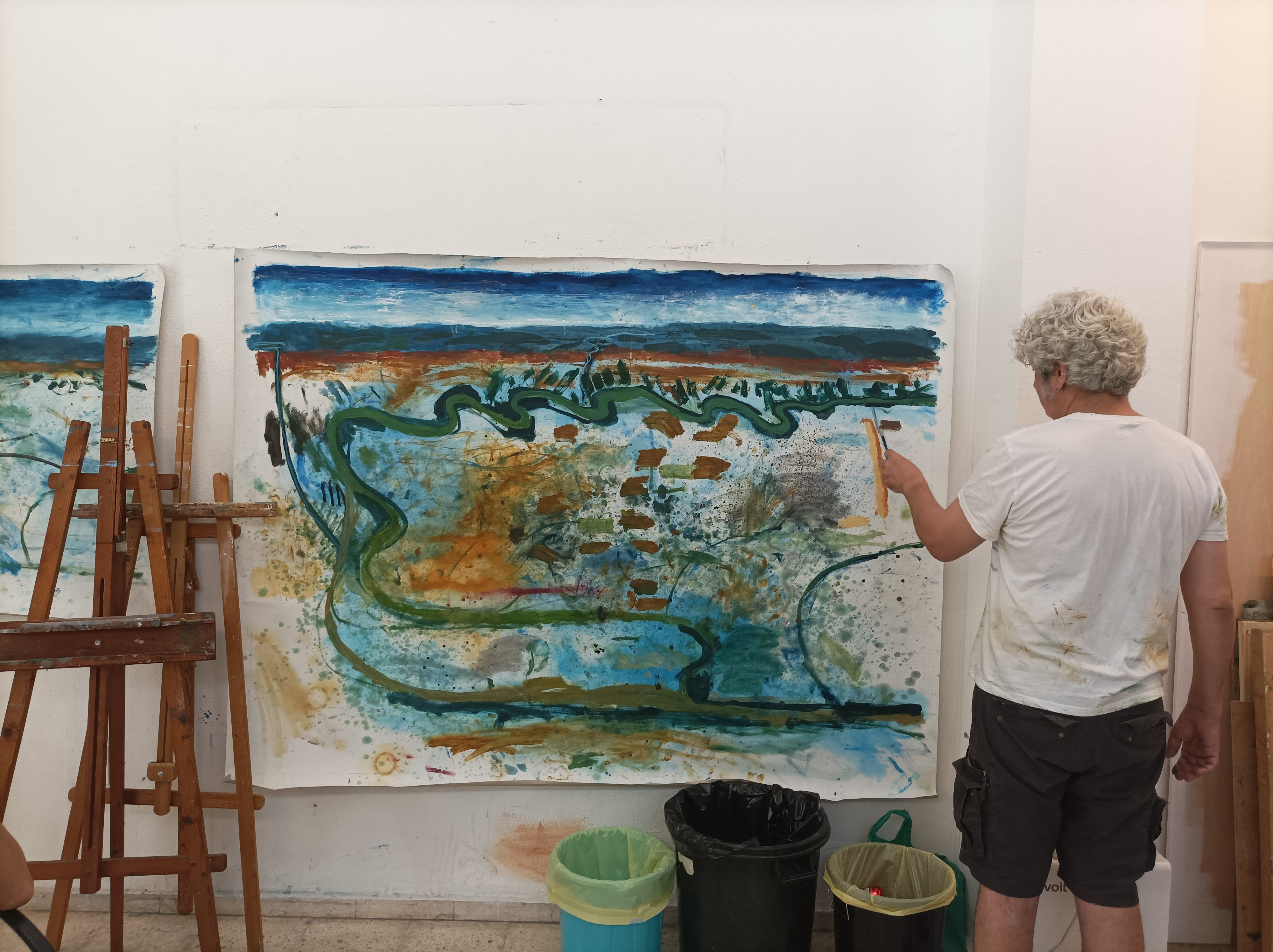
In his studio, David López Panea stands before a vast canvas where water bends and coils in shades of green and blue. The painting reimagines the wetlands of Tablada, in Seville, as a living body—fluid, shifting, and resistant to rigid lines. Broad strokes and layered textures suggest a territory in motion, a landscape that cannot be confined without consequence. The artist’s gesture becomes both interpretation and warning: nature is not a backdrop, but a force with memory and rhythm.
Tablada is a floodplain of high ecological value, shaped by periodic inundation and sediment dynamics. For more than two decades, scientists have documented the flood-prone character of its approximately 360 hectares and cautioned against engineering interventions designed to suppress its natural hydrology. Floodplain soils typically display hydromorphic features—such as gleying, mottling, and variable redox conditions—reflecting cycles of saturation and drying. These processes sustain wetland biodiversity, regulate water storage, and buffer extreme rainfall events. Constructing dikes to enable urban development would disrupt sediment flows, alter soil functions, and increase downstream flood risk. Across Europe, wetland restoration and “room for the river” strategies are increasingly recognized as more sustainable alternatives to hard infrastructure in flood management (e.g., European Environment Agency reports on nature-based solutions).
Ahora, en español:
En su taller, David López Panea se sitúa ante un gran lienzo donde el agua serpentea en verdes y azules. La obra reinterpreta el paisaje de Tablada, en Sevilla, como un cuerpo vivo: fluido, cambiante y ajeno a las líneas rígidas. Las pinceladas amplias y las texturas superpuestas evocan un territorio en movimiento, un paisaje que no puede ser contenido sin consecuencias. El gesto del artista es interpretación y advertencia: la naturaleza no es un decorado, sino una fuerza con memoria y ritmo.
Tablada es una llanura de inundación de alto valor ecológico, modelada por pulsos periódicos de agua y por la dinámica de los sedimentos. Desde hace más de dos décadas, la comunidad científica ha documentado el carácter inundable de sus aproximadamente 360 hectáreas y ha alertado sobre los riesgos de intervenir su hidrología para posibilitar la urbanización. Los suelos de llanura de inundación presentan rasgos hidromórficos —como gleización, moteados y condiciones redox variables— que reflejan ciclos de saturación y secado. Estos procesos sostienen la biodiversidad, regulan el almacenamiento de agua y amortiguan episodios de lluvia intensa. La construcción de diques para anular su dinámica natural alteraría los flujos de sedimentos, modificaría las funciones edáficas y podría incrementar el riesgo de inundación aguas abajo. En Europa, las estrategias basadas en soluciones naturales y en “dar espacio al río” se consideran alternativas más sostenibles frente a infraestructuras rígidas.
Categories
Location
- Europe (3936)
- Southern Europe (1713)
- Spain (841)
- Exact location (-5.9957 W, 37.3737 N)
Tags
Colours
Image properties
4000 × 2992 px;
image/jpeg; 1.0 MB
Camera:
Xiaomi M2103K19G
Taken on 13
July
2022
Submitted on 9 November 2022
Licence
Creative Commons Attribution-ShareAlike 3.0 Unported (CC BY-SA 3.0)
Credit
Antonio Jordán (distributed via imaggeo.egu.eu)
Share
Appreciate
Report