Mediterranean Luvisols: back to the future
by Antonio Jordán, University of Seville, Sevilla, Spain
First, in English:
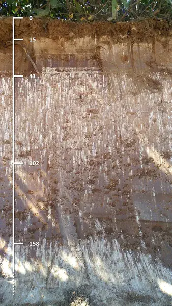
The picture shows a Luvisol with calcic accumulations at different depths, in and below an argic horizon. Overlapping of decarbonation processes is a witness of different aridification stages.
During the Miocene, the climate was very hot and rainy. This favoured the calcium carbonate present in the soil (from both the rock and the dissolution of CO₂ produced by the respiration of soil microorganisms) to be "dragged" down by the rain. You can find that accumulation starting at 158 cm depth in the image. By “freeing” the calcium carbonate, the clay could also be mobilized, and it was also displaced by the rain, accumulating in a horizon between 102 and 158 cm deep, just above the white calcium-rich horizon. With water and high temperature, chemical reactions accelerate, so that the clay was chemically altered and released iron, which oxidized and gave that striking red colour. Then… climate changed! It went from a 12-months hot and rainy climate to a warm climate only in summer and cold and rainy only in winter (what we commonly call Mediterranean climate). During summer, heat made the evaporation of the water very intense, so that instead of going down, it began to go up (as in drink straws, those straws that you shouldn't buy anymore because plastic contaminates). The intensity with which the water rose dragged calcium carbonate upwards again, forming a second (in time) calcareous horizon between 41 and 102 cm depth.
Ahora, en español:
La imagen muestra un Luvisol con acumulaciones cálcicas a diferentes profundidades, dentro y debajo de un horizonte árgico. La superposición de los procesos de descarbonatación es testigo de diferentes etapas de aridificación.
Durante el Mioceno, el clima era muy cálido y lluvioso. Eso favoreció que el carbonato de calcio presente en el suelo (proveniente tanto de la roca como de la disolución del CO₂ producido por la respiración de los microorganismos del suelo) fuese “arrastrado” hacia abajo por la lluvia. Esa es la acumulación que se ve a partir de los 158 cm de profundidad en la imagen. Al “liberarse” del carbonato de calcio, la arcilla pudo también movilizarse, y fue desplazada también por la lluvia, acumulándose en un horizonte entre 102 y 158 cm de profundidad. Con agua y temperatura alta, las reacciones químicas se aceleran, de modo que la arcilla se alteró químicamente y liberó hierro, que se oxidó y dio ese color rojo que tan bien se aprecia. Entonces… ¡cambió el clima! Pasamos de un clima cálido y lluvioso todo el año a otro cálido solo en verano y lluvioso solo en invierno (lo que llamamos comúnmente clima mediterráneo, vamos). En el verano, el calor hizo que la evaporación del agua fuese muy intensa, de modo que en vez de hacia abajo, comenzó a ir hacia arriba (como en las pajitas para las bebidas, esas pajitas que usted ya no debería comprar porque el plástico contamina). La intensidad con que el agua subía comenzó a arrastrar el carbonato de calcio de nuevo hacia arriba, formándose un segundo (en tiempo) horizonte calcáreo entre 41 y 102 cm de profundidad.
Categories
Location
- Europe (3883)
- Southern Europe (1683)
- Spain (811)
- Exact location (-5.8527 W, 37.5454 N)
Tags
- soil profile (122)
- luvisol (6)
- mediterranean soils (265)
- climate change (69)
- cropped soil (74)
- arid soils (34)
Colours
Image properties
720 × 1280 px;
image/jpeg; 391.6 KB
Camera:
Huawei HUAWEI MLA-L01
Taken on 11
June
2019
Submitted on 17 June 2019
Licence
Creative Commons Attribution-ShareAlike 3.0 Unported (CC BY-SA 3.0)
Credit
Antonio Jordán (distributed via imaggeo.egu.eu)
Share
Appreciate
Report